Kooky Little Map Tool

epanzella

Active User
Registered
Joined
Apr 8, 2013
Messages
2,021
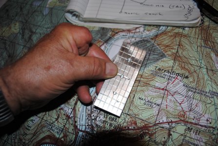
Hunting season is here! My TOPO maps only have lat/long grid lines every 15 seconds. This makes for some pretty big boxes with a lot of geography inside each one. When scouting I like to pick out promising spots on the map and then put the coordinates in my GPS so I can go right to them even though I had never been there. In the past I always cut out cardboard templates and then marked them up with a pen to help me extrapolate precise coordinates with in the boxes. This is very tedious and the cardboard map aide doesn't last very long so I'm always making new ones. I decided to make one out of aluminum but the problem of holding the part and scribing it precisely proved difficult with my damaged left hand. Then I thought of my mill and DRO. I took a tungsten on it's last legs out of my TIG and stuck it in a collet. Then using the power feed and the DRO I was able to scribe the part accurately in about 20 minutes without ever turning the machine on. DSC_0144.JPG
 
Your "grid scale device" (GSD) does look like a useful gadget.
But a few cautions to the less experienced navigators:
Except near the equator, a second (or minute, or degree) of longitude is less than the same angular measure of latitude. The further you go toward the poles. This means you have to design your GSD device for the approximate latitude for where you'll use it. Look carefully at epanzella's GSD and you can see his latitude lines are spaced farther apart than the longitude ones, in same proportion as the map's rectangles. And it means you must remember this when you use the GSD, and orient it correctly. Maybe a "N" should be inscribed on the upper edge?

Greg
Right you are, sir. If you took a basketball and drew horizontal and vertical lines the horizontal lines would remain relatively parallel but the vertical lines would be far apart at the centerline (equator) yet would be touching at the top and the bottom of the ball. (North pole/South pole). This is why I make a tool that's optimized for the area I'll be hunting. I do have a store bought tool that compensates for this but using it is very tedious. It only has one set of grid marks to extrapolate both latitude and longitude but you have to tilt it at the correct angle for your location to make it work accurately. There are aides on the map to help you do this but as soon as you move it you have to reacquire the angle again or your navigation will be off. My tool can be read directly as long as it's parallel to the lines on the map. I'm 73 and I'm on foot so I want to get to the right spot on the first try!**** ps. If by marking "N" you mean NORTH that's not necessary as the tool has the same aspect ratio as the grid lines and it would be obvious if you were holding it incorrectly.
 
Last edited:
Back
Top